


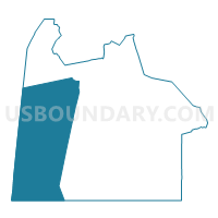
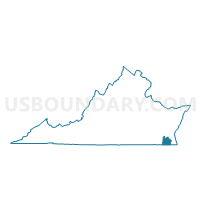
Deep Creek Voting District, Chesapeake city, Virginia
About
Outline

Summary
| Unique Area Identifier | 682811 |
| Name | Deep Creek Voting District |
| County | Chesapeake city |
| State | Virginia |
| Area (square miles) | 87.39 |
| Land Area (square miles) | 82.75 |
| Water Area (square miles) | 4.63 |
| % of Land Area | 94.70 |
| % of Water Area | 5.30 |
| Latitude of the Internal Point | 36.63107220 |
| Longtitude of the Internal Point | -76.40508190 |
Maps

Graphs
Select a template below for downloading or customizing gragh for Deep Creek Voting District, Chesapeake city, Virginia


Neighbors
Neighoring Voting District (by Name) Neighboring Voting District on the Map
- Bells Mill Voting District, Chesapeake city, VA
- Bethel Voting District, Chesapeake city, VA
- Cypress Chapel Voting District, Suffolk city, VA
- Gilmerton Voting District, Chesapeake city, VA
- Grassfield Voting District, Chesapeake city, VA
- John T. West Voting District, Chesapeake city, VA
- Lake Drummond Voting District, Chesapeake city, VA
- Shipyard Road Voting District, Chesapeake city, VA
- Voting District SM, Camden County, NC
- Sunray Ii Voting District, Chesapeake city, VA
- White Marsh Voting District, Suffolk city, VA
Top 10 Neighboring County Subdivision (by Population) Neighboring County Subdivision on the Map
- Chesapeake city, Chesapeake city, VA (222,209)
- Suffolk city, Suffolk city, VA (84,585)
- South Mills township, Camden County, NC (3,652)
Top 10 Neighboring Place (by Population) Neighboring Place on the Map
Top 10 Neighboring Unified School District (by Population) Neighboring Unified School District on the Map
- Chesapeake City Public Schools, VA (222,209)
- Suffolk City Public Schools, VA (84,585)
- Camden County Schools, NC (9,980)
Top 10 Neighboring State Legislative District Lower Chamber (by Population) Neighboring State Legislative District Lower Chamber on the Map
- State House District 76, VA (92,939)
- State House District 1, NC (78,595)
- State House District 77, VA (76,927)
- State House District 81, VA (74,455)
Top 10 Neighboring State Legislative District Upper Chamber (by Population) Neighboring State Legislative District Upper Chamber on the Map
- State Senate District 14, VA (199,147)
- State Senate District 1, NC (179,312)
- State Senate District 18, VA (174,793)
Top 10 Neighboring 111th Congressional District (by Population) Neighboring 111th Congressional District on the Map
Top 10 Neighboring Census Tract (by Population) Neighboring Census Tract on the Map
- Census Tract 213.02, Chesapeake city, VA (9,658)
- Census Tract 214.02, Chesapeake city, VA (6,317)
- Census Tract 212, Chesapeake city, VA (5,730)
- Census Tract 213.01, Chesapeake city, VA (5,396)
- Census Tract 9501.01, Camden County, NC (5,324)
- Census Tract 214.01, Chesapeake city, VA (2,028)
- Census Tract 756.02, Suffolk city, VA (1,397)